Locality Insights
Haji Ali Dargah in Mumbai: History, Timings, and Location
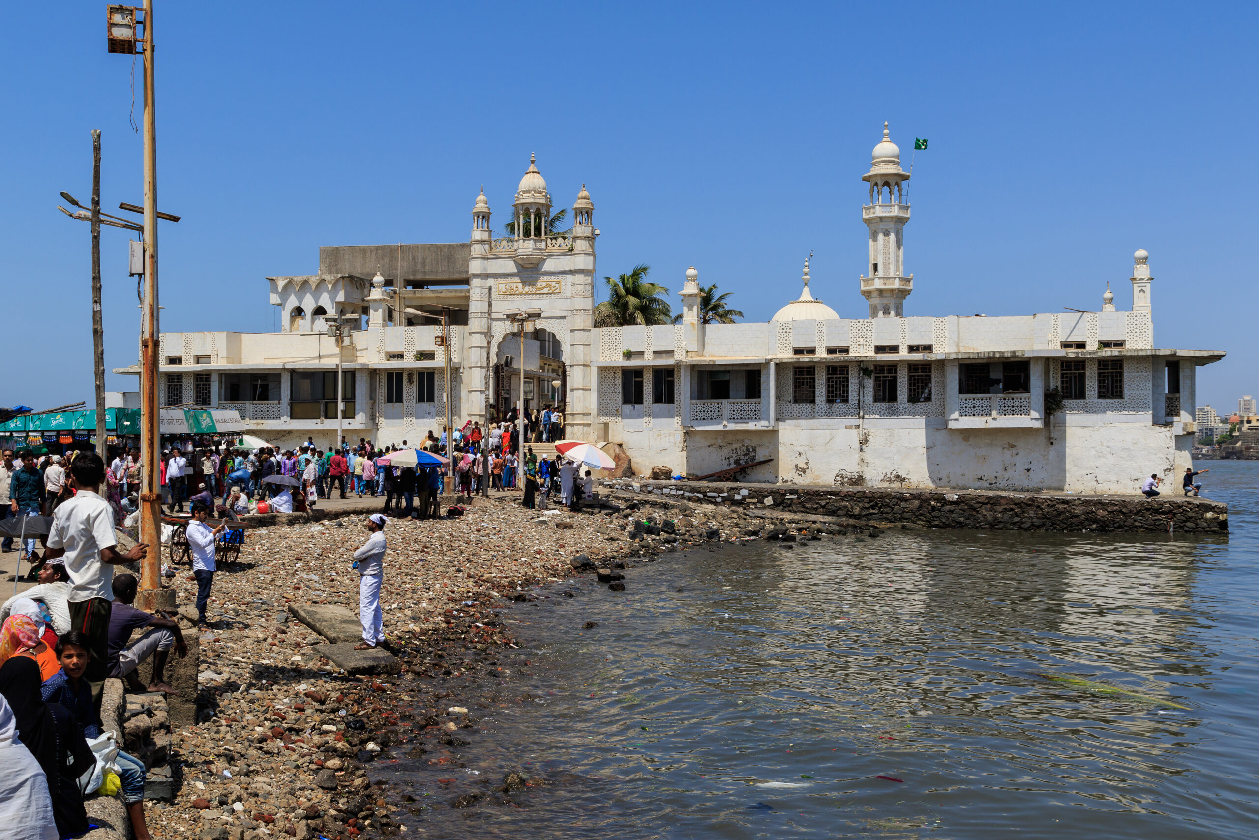
Haji Ali Dargah, one of the most well-known Islamic shrines, exemplifies the Indo-Islamic architectural style. The Haji Ali Dargah is well-known for its stunning setting, architectural beauty, and religious significance. It houses the mortal remains of Pir Haji Ali Shah Bukhari, a 15th-century Sufi saint. The mosque, set against the stunning Arabian Sea, looks to be floating on water. Haji Ali Dargah, one of the top locations to visit near Mumbai, located around 6 kilometers from Mumbai’s Chhatrapati Shivaji Terminus. Here’s everything you need to know about the Haji Ali Dargah in Mumbai, including its architecture, history, and opening hours.
Haji Ali Dargah – Architecture
This beautiful Dargah in Mumbai, spread over 4,500 square meters and 85 feet in height, is created with ‘Makrana’ marble, the same marble used in the Taj Mahal structure. The shrine houses two monuments: a mosque and Pir Haji Ali Shah Bukhari’s mausoleum. The monument is ringed by eight marble pillars and coated in silver frames on all sides. The structural design of Mumbai’s iconic Dargah reflects Indo-Islamic and Mughal architectural influences. Due to its unusual and stunning location, the road to the mosque becomes buried in water during high tide, rendering it inaccessible.
The main hall of the Haji Ali Dargah is surrounded on three sides by three halls: south, west, and east. While the west hall is restricted for ladies, men may pray in the east hall. The marble ceiling of the center hall is embellished with mirror work and etched with 99 distinct names of Allah. In addition, the main hall’s walls and ceilings are inscribed with Quran Sharief phrases. The mosque also has a three-story sanatorium and a separate Qawwal Khana. The Haji Ali Masjid is connected to the seaside by a 700-yard boardwalk. There are no railings on either side of the pavement, so tourists are thrilled when the sea’s waves crash against the pathway. At night, the mosque lights up in the distance, surrounded by nothing but the majestic Arabian Sea, creating a heavenly scene. It appears to be floating in the water, with no tie to the mainland.
Haji Ali Dargah – History
Sayyed Pir Haji Ali Shah Bukhari, a 15th-century Sufi saint, founded Mumbai’s famed Dargah. He was a wealthy businessman from Bukhara, located in modern-day Uzbekistan. Just before departing for Mecca, he made the decision to give up all of his earthly wealth and worldly things in order to become a saint. Later, he traveled the world and eventually settled in Mumbai, A mystical legend of Haji Ali Dargah states that the Sayyed Peer once came upon a destitute lady crying on the road while holding an empty pot. The lady used to sell oil, but one day she unintentionally split it on the road. Haji Ali returned to the same area, jabbing his fingers into the ground. The oil oozed from the dirt, and the lady refilled the vessel before thanking the saint.However, the saint had a troubling dream that night, believing that his actions had harmed the earth. He was filled with regression and grief, which damaged his health as well. Later, he traveled to India and arrived at the Mumbai beach. He wanted to remain in Mumbai permanently and raise Islam awareness over the world.
However, the saint had a troubling dream that night, believing that his actions had harmed the earth. He was filled with regression and grief, which damaged his health as well. Later, he traveled to India and arrived at the Mumbai beach. He wanted to remain in Mumbai permanently and raise Islam awareness over the world.
Another historical fact is that Haji Ali Dargah is related with the Saint’s death. It is reported that he instructed his disciples not to bury him straight away after his death, but rather to dump the casket into the water and later bury the body in the precise location where it was found. The saint’s devotees did the same, and his coffin was discovered on a mound near Worli. The Haji Ali Masjid and the saint’s tomb were later built on the same site. Today, the tomb has become a well-known mosque where people of various faiths visit to seek blessings.
Haji Ali Dargah- Timings
Haji Ali Dargah is open every day of the year, from 5:30 a.m. until 10:00 p.m. However, the greatest time to see this lovely mosque is between October and March, when tides are lower and easier to approach. This mosque receives approximately 40,000 visits every day, with Thursdays and Fridays being particularly busy. You can also visit this Dargah to participate in the ceremonies of Islamic festivals such as Ramzan and Eid. Aside from that, the yearly Urs, or death anniversary of Sayyed Pir, is the most significant event here. Remember that this famous Dargah in Mumbai can be reached during low tides via a walkway surrounded by sea on all sides.
How to Reach Haji Ali Dargah
Visitors can access the Dargah by taking busses or taxis to Worli Bay and then walking up to the mosque.
Via Air – The Dargah is about 20 kilometers from the Mumbai airport.
Via Sea – The Haji Ali Dargah, located near the Worli Sea Link, is accessible by any water transportation option or taxi.
The mosque is well-connected by train. So you can go there from Mumbai Central, Byculla, and Mahalaxmi Stations.
Tourist Attractions near Haji Ali Dargah in Mumbai
Marine Drive
Marine Drive, also known as Netaji Subhash Chandra Bose Road, is considered the pride of Mumbai, the City of Dreams. This stunning location, 5.2 kilometers from Haji Ali Dargah, is also known as the Queen’s Necklace because streetlights along the vast shoreline resemble a necklace of glittering pearls, producing a virtual impression of a necklace. You can visit this location to enjoy the natural beauty, take stunning photos, and eat some local specialties.
Siddhi Vinayak Temple
The Siddhi Vinayak temple, located 6.2 kilometers from Haji Ali, is a highly renowned sanctuary dedicated to Lord Ganesh. The temple has a modest sanctum with the idol of Shri Ganesha, which is constructed from a single piece of black stone. It is claimed that the Lord Ganesha statue manifests itself and fulfills followers’ wishes.
Nehru Planetarium
The Nehru Planetarium, which is part of the Nehru Centre, is well-known for its astronomical and scientific educational programs. The Planetarium was designed by architect J M Kadri and features a cylindrical construction with a spectacular dome. The Nehru Planetarium, located 2.5 kilometers from the Haji Ali Mosque, includes some sets that allow visitors to witness astronomical occurrences such as eclipses. So, if you are interested in science and space, don’t miss the Nehru Planetarium in Mumbai.
Chowpatty Beach
Chowpatty Beach, one of Mumbai’s most popular tourist attractions, is located approximately 3.4 kilometers from the Haji Ali Dargah. Watching the magnificent sunsets is an experience worth having at least once in a lifetime. You can also enjoy various recreational activities such as a camel ride, merry-go-round, ferris wheels, and pony rides. This Mumbai tourist destination is well-known for its stalls selling mouthwatering Bhel-Puri, as well as other delightful selections such as Pav Bhaji, Chat, Pani Puri, Golas, and Kulfi.
Elephanta Caves
The Elephanta Caves, also known as Gharapurichi Leni, are located on Elephanta Island in Mumbai. The Elephanta Caves, designated as a UNESCO World Heritage Site in 1987, are the pinnacle of Indian architecture, with Indian mythology represented in every corner. The cave temple complex spans 60000 square feet and houses the major chamber, courtyards, and various minor shrines. When visiting Mumbai, be sure to add the Elephanta Caves in your itinerary to experience the spiritual and historical marvels.
In addition, you can visit the Chhatrapati Shivaji Maharaj Vastu Sangrahalaya, Worli Fort, Jehangir Art Gallery, Colaba Causeway, and Gateway of India.
Mumbai’s Bandra Kurla Complex (BKC) is preparing to launch a new program aimed at decreasing congestion and encouraging sustainable travel. Every Friday will be designated as ‘Public Transport Day’, with approximately 200,000 professionals encouraged to take the train, metro, or bus instead of driving their own cars. The program, a first-of-its-kind initiative centered on a major corporate district, will begin this week, on June 12.
Why was Friday chosen?
Around 90 BKC-based firms and organisations have shown their support in principle to the initiative. It is being implemented by the Mumbai Metropolitan Region Development Authority (MMRDA) in collaboration with BEST, Mumbai Metro Rail Corporation Limited (MMRCL), the Traffic Police, auto-rickshaw unions, and WRI India, according to the Hindustan Times (HT).
According to authorities, Fridays were chosen because work schedules are often more flexible near the end of the week, making employees more ready to try other transport options. Mondays were avoided since commuters are normally under more strain to get to work on time.
The MMRDA has also directed almost 2,000 employees and contract workers to engage in the campaign.
How long will the trial last?
Officials stated that the program will be rigorously watched for at least three to four months. During this time, authorities will assess difficulties every week and implement changes as needed.
The move comes after surveys and stakeholder consultations conducted in recent weeks. According to the findings, 82% of commuters would consider taking public transportation if services were more reliable, convenient, and well-connected.
What issues are commuters most concerned about?
According to feedback obtained during conversations, the most pressing issues concern last-mile connectivity from Aqua Line metro stations, pedestrian amenities within BKC, a lack of shade for pedestrians, and the need for more regular BEST bus services.
“Getting out of the metro station is quick, but finding a shared auto or a feeder bus to cover the remaining one to two kilometers inside BKC is a daily nightmare,” an executive from a big financial firm told HT.
“If last-mile connectivity isn’t smooth, people will naturally return to their vehicles. There is a need for robust bus services with frequencies of 5-10 minutes instead of the current 20-25 minutes.”
Why do so many commuters still use private vehicles?
According to MMRDA officials, poor last-mile connectivity remains a significant barrier.
“There are challenges with last-mile connection in BKC, therefore 52% of visitors still rely on personal cars, taxis, and auto-rickshaws. Furthermore, more than half of BKC’s 200,000 employees spend more than two hours commuting each day. We will also consult with the auto-rickshaw unions to ensure that this plan is effective,” an MMRDA official told HT.
According to studies provided during debates, 52% of commuters still rely on private vehicles, taxis, and auto-rickshaws, while only 25% use public transportation on a daily basis.
Experts cited poor last-mile connections from Aqua Line stations and insufficient pedestrian infrastructure as major causes for low public transportation usage.
What upgrades are planned?
Authorities and partner agencies have been working with BKC businesses to find urgent and long-term solutions.
Dedicated turning facilities for BEST buses at major junctions are one of the concepts being considered to increase service efficiency. Officials are also looking into whether internal roadways on large office campuses may be made pedestrian-friendly to provide shorter walking routes.
Urban mobility experts indicated that boosting walkability will be critical to the initiative’s success. They observed that walking in BKC is uncomfortable due to the broad concrete expanses and lack of tree protection, especially in hot weather.
Planners have proposed shaded pedestrian pathways, more tree cover, and better connections between metro stations and office buildings.
“There are long-term plans such as all-weather footpaths as well wherein we can have shades with plants overarching the roofs, mist blowers and plain footpath among other things,” an urban planner stated.
How will you persuade staff to participate?
Officials and corporate representatives have also explored incentives for behavioral change. Regular public transportation users could benefit from reward systems, recognition programs, and travel expense compensation.
“Meaningful change starts with each of us. My entire staff and I have committed to supporting this initiative by taking public transportation on Fridays. Dr Sanjay Mukherjee, metropolitan commissioner of MMRDA, told HT that even little changes can dramatically cut congestion and pollution.
Walking Project’s programme manager, Vedant Mhatre, applauded the effort, saying it might assist enhance both public transportation utilization and walking conditions in BKC.
“The project acknowledges the need to shift more trips to public transportation. We hope it will also provide an opportunity to make basic but significant changes to BKC’s walking infrastructure, such as safer junctions, better walking corridors, improved shading, and increased pedestrian comfort. These steps can considerably improve the experience of walking and taking public transportation. We are thrilled that MMRDA has taken the lead on this endeavor, and the Walking Project is eager to contribute feedback, suggestions, and practical improvements.”
Introduction
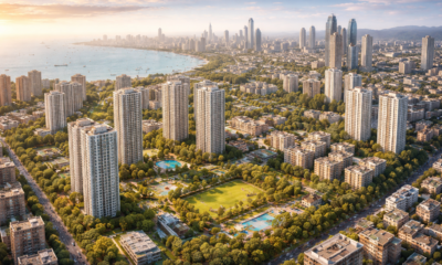
Mumbai offers a variety of options, from luxury real estate to mass housing constructions. The city offers housing options for people of all income levels and strikes the perfect mix between elegance and reality. Mumbai’s inexpensive cost of living, abundant employment opportunities, and advanced infrastructure make it a desirable destination for prospective homebuyers. If you’re looking for a home in a posh part of Mumbai, here are some of the city’s most expensive neighborhoods.
Top 7 Posh Areas in Mumbai.
These are the top seven posh areas in Mumbai where buying a home can be quite expensive. However, the quiet surroundings and sea views from high-rise buildings are worth the cost.
Juhu
Juhu, sometimes known as Bollywood’s Beverly Hills, is an upmarket enclave in Mumbai’s western suburbs. There are a range of independent builder levels and low-rise structures. The Arabian Sea to the west offers spectacular views of nature. Furthermore, the neighborhood has exceptional connection, superb infrastructure, and first-class amenities.
Malabar Hill
Malabar Hill is another affluent suburb in Mumbai’s southern zone. Aside from being a prominent residential community. It is the most expensive site in Mumbai, situated on the city’s southern tip and offering views of the Arabian Sea on three sides. The primary attractions are Seaside Chowpatty and the Hanging Gardens. Furthermore, the area has a wide range of social amenities and world-class physical infrastructure.
Cuffee Parade
Cuffe Parade, located at Nariman Point in the city’s south end, was constructed on 75,000 square metres of land on Colaba’s western bank. Today, it is one of Mumbai’s most affluent neighborhoods. Maker Towers, the World Trade Center, and the Taj President Hotel are among the region’s residential and business high-rises. What identifies it as a luxury neighborhood in Mumbai is the presence of first-rate amenities and well-maintained infrastructure.
Bandra West
Bandra West is another Mumbai VIP area with a wide range of property options. It is especially well-known for its famous homes. In addition to being a rich district in Mumbai, it is a popular entertainment destination, having a variety of high-end restaurants, discotheques, and nightclubs. Furthermore, it is well connected to Worli by the Bandra-Worli Sea Link and has excellent medical services and schools.
Pali Hill
Palli Hill is an upscale area named after the Pali village in Bandra. It runs across Naushad Ali Road (previously Carter Road) and has a variety of complexes, restaurants, and bungalows with steep and shallow sides. Furthermore, it boasts cutting-edge infrastructure and convenient access to all modern facilities.
Worli
Worli, one of Mumbai’s four peninsulas, is a well-connected neighborhood in southern Mumbai. It is home to several celebrities. The region is surrounded by high-rise buildings with panoramic views of the Bandra-Worli Sea Link, the Race Course, and the Arabian Sea. Aside from being Mumbai’s most upscale neighborhood, it is home to a diverse range of commercial establishments, including restaurants, nightclubs, and shopping malls. Its proximity to commercial centers makes it a popular choice for office workers.
Colaba
Colaba is another popular residential neighborhood in Mumbai. It is a separate district that acts as the city’s art and cultural center. Colaba is a heritage district that includes high-end boutiques, museums, theatres, art galleries, and colonial structures. Aside from its excellent connectivity, Colaba is home to some of the top educational and healthcare institutions.
The Most Expensive Areas in Mumbai: Real Estate Prices
Mumbai is a booming metropolis with a steady demand for real estate. Scarce land resources due to surrounding water bodies aggravate competition and drive up housing prices. Real estate prices in Mumbai are higher in areas with scenic views, entertainment attractions, and commercial districts. Homebuyers must pay higher prices for properties in areas with adequate infrastructure, public facilities, transit networks, and convenient access to highways and airports.
Price Trend of Posh Areas in Mumbai
While Mumbai is one of the most expensive cities in India to buy a home, some areas have exorbitant real estate prices. Cuffe Parade, Pali Hill, Bandra, Malabar Hill, and Colaba are some of Mumbai’s most expensive suburbs. However, high real estate prices may not always indicate a healthy property market. The Mumbai property market has slowed in recent years due to the pandemic and the economic downturn. Despite this, a premium neighbourhood in Mumbai continues to entice wealthy investors and buyers with its unique features. These neighborhoods offer class and distinction, which many homeowners are ready to pay for.
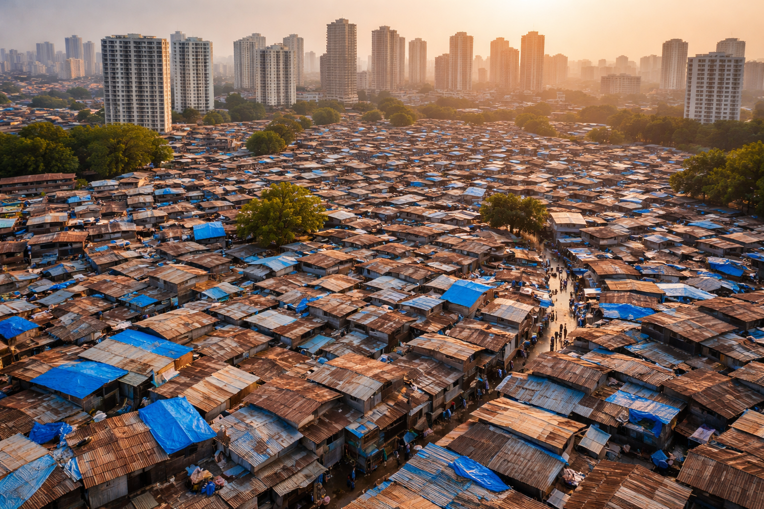
Mumbai’s slum cover: Areas such as Mankhurd-Deonar, Dahisar and Malad have seen large-scale encroachments, according to new findings by the SRA
Slums now occupy nearly 24% of Mumbai’s land and house more than half of its population, according to findings by the Slum Rehabilitation Authority (SRA).
The survey also found that approximately 58 hectares of collector or government land had been encroached upon over the past 14 years. Officials noted that the total encroached area across land owned by other authorities could be significantly higher, as reported by the Hindustan Times newspaper.
To map the extent of encroachments, the SRA used satellite imagery and GIS, comparing images from 2000 with GIS data from 2011 and 2025.
The data has been shared with the Mumbai city and suburban collectorates. Additionally, the data will also be shared with the Mumbai Civic Body, the Brihanmumbai Municipal Corporation (BMC) and other land-owning authorities, including private landlords and central government establishments, the report said.
Affected areas in the Mumbai real estate market
The SRA findings reveal that more than 8,000 square metres of mangroves behind the World Trade Centre at Cuffe Parade in South Mumbai were encroached upon between 2011 and 2025. In Mankhurd-Deonar, a nullah has been almost entirely taken over, with slum structures covering over 18,800 sqm.
Ganpat Nagar in Eksar has seen encroachments exceeding 22,000 sqm since 2011, while large patches in Malvani have also been occupied, according to the SRA findings.
The SRA findings reveal that areas covering patches such as Masjid Bunder, Dongri, and Bhendi Bazaar in south Mumbai have recorded the lowest percentage of slum encroachments since 2011, while suburban pockets such as Kurla, Deonar, Malvani, and Dahisar have seen a much higher rise.
Mumbai’s population and land size
According to data released by Knight Frank India in September 2025, Mumbai’s population is 13.4 million, and the city’s land area is 437 sq km, with a density of 30,600 per sq km.
All about the Slum Rehabilitation Authority
The Slum Rehabilitation Authority (SRA) is a government body responsible for implementing slum redevelopment projects in Maharashtra. Established in 1995, it enables private developers to provide free housing to slum dwellers while allowing them to build and sell additional apartments on the same land to recover project costs. Instead of rehabilitating slum dwellers, developers obtain additional construction rights, enabling them to build more flats to sell in the open market.
What are slums, and are they legal?
Slums in Mumbai are densely populated informal settlements where residents often lack secure housing tenure and basic services like sanitation, water, and drainage. They house a significant portion of the city’s population, providing affordable living close to jobs, and remain central to urban planning and redevelopment efforts.
According to SRA rules, slums that arose before January 1, 2000, are eligible for free rehabilitation housing under the SRA scheme. However, slums built between January 1, 2000 and January 1, 2011, are protected from eviction but are eligible for rehabilitation on a construction cost payment basis, and slums that have come up after the 2011 cutoff are considered illegal and liable for action.

Reliance Wins 101-Acre Mumbai Slum Redevelopment Project

Kriti Sanon Family Sells Andheri Flats for ₹8.9 Cr

Mumbai Tenant Loses ₹1 Lakh Deposit Over Repainting Row

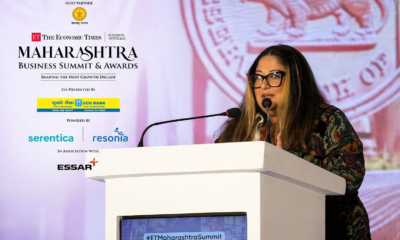
Vijayta Raheja Applauds India’s ₹4 Lakh Crore Urban Vision at ET Maharashtra Business Summit

Mumbai’s Largest MHADA Redevelopment Drive Set to Transform 923 Acres

John Abraham Firm Renews Bandra Rent at ₹12L/Month
-
 Real Estate News2 months ago
Vijayta Raheja Applauds India’s ₹4 Lakh Crore Urban Vision at ET Maharashtra Business Summit
-
 Real Estate News2 months ago
Mumbai’s Largest MHADA Redevelopment Drive Set to Transform 923 Acres
-
 Real Estate News2 months ago
John Abraham Firm Renews Bandra Rent at ₹12L/Month
-

 New Projects & Launches2 months ago
K Raheja & IHG Team Up to Elevate Powai’s Hospitality Landscape
-
 Global Real Estate2 months ago
Northfield Sees New Affordable Housing Underway
-
 Global Real Estate2 months ago
Spanish Youth Hostel Group Considers London Real Estate Deals
-
 Real Estate News2 months ago
Lower Parel Sees ₹60Cr+ Luxury Property Boom
-

 NRI Real Estate2 months ago
How NRIs Are Driving India’s Property Market?