
Locality Insights
Top 5 Reasons to Visit Keiv Ukraine
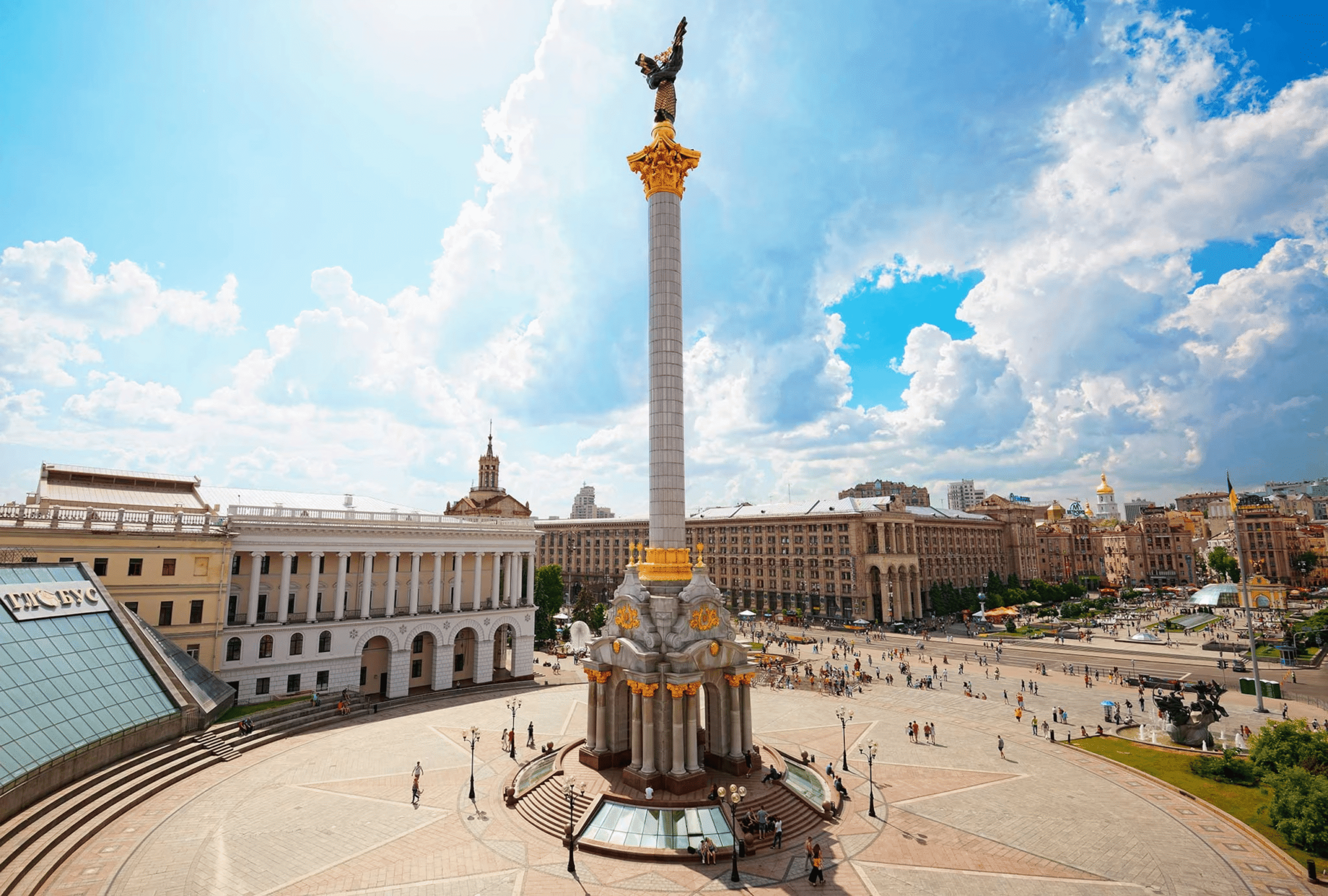
Kiev is Ukraine’s vibrant capital and largest metropolis, sprawling across both sides of the Dnieper River. This combination of antique and modern buildings is home to three million people. Kiev’s stunning cathedrals and monasteries spill out onto cobblestone streets and lush green spaces and parks. Although many buildings were demolished during the Communist occupation, some of Ukraine’s exquisite architecture survived and stands as a tribute to the city’s tenacity.
Kiev – or Kyiv – was first known as Kievan Rus in the 5th century and saw its peak prosperity during the 11th and 12th centuries, when it served as a major commercial route between the Baltic and Mediterranean. The following are the top five reasons to visit Kiev.
1. St. Sophia Cathedral
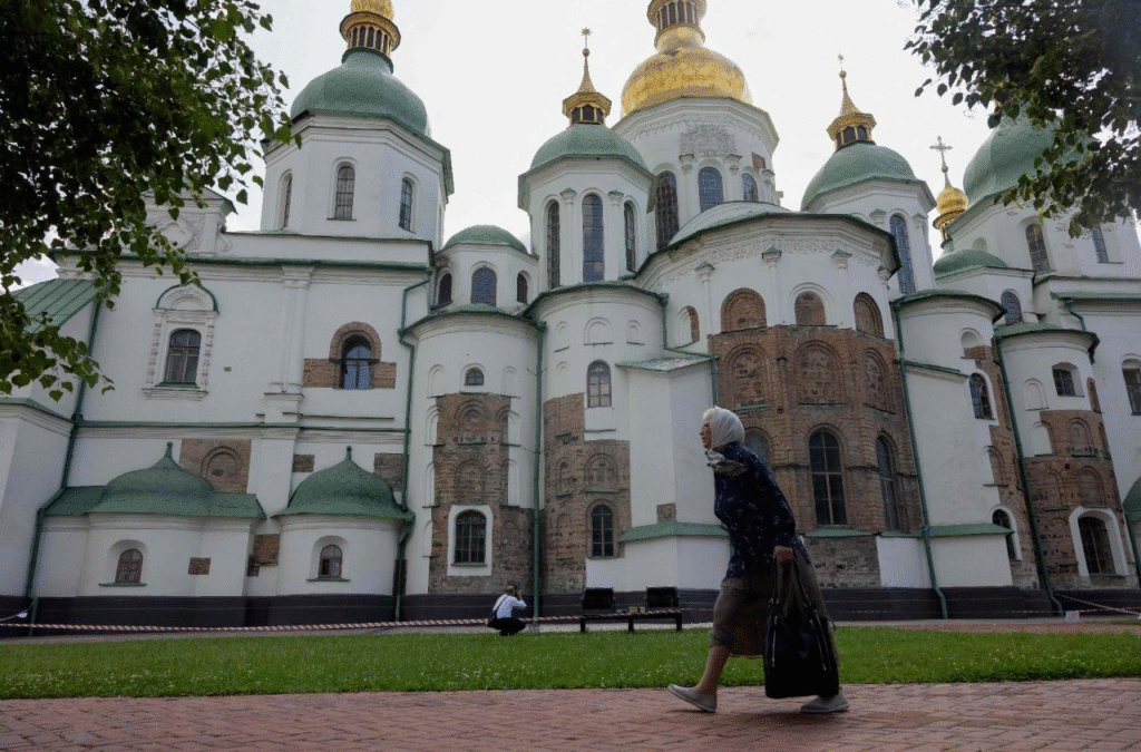
St. Sophia, named after Istanbul’s famous Hagia Sofia, was Ukraine’s first UNESCO World Heritage site and a local landmark. In addition to the beautiful green and gold-domed cathedral, the complex features a bell tower and the Metropolitan House.
Centuries before the Czars, Kiev was the hub of Slavic mysticism. Prince Yaroslav the Wise began construction on the Byzantine cathedral, Kiev’s oldest church, about 1037, but it took two decades to complete. In Kiev’s splendor, the princes were crowned at St. Sophia, and the Kievan rulers were buried there.
In modern times, the church has been the subject of controversy, with many religious factions claiming ownership. In 1995, a brutal mob disrupted Patriarch Volodymyr’s funeral, preventing the burial on the premises. As a result of this occurrence, the church no longer hosts services and now operates a secular museum of Byzantine history and architecture.
2 Pechersk Lavra

Pechersk Lavra (also known as the Monastery of the Caves), an 11th-century UNESCO World Heritage site and one of Ukraine’s Seven Wonders, is a must-see in Kiev. The large sacred grounds include cathedrals, chapels, monasteries, catacombs, tunnels, and a bell tower.
The site comprises a labyrinth of small vaults with open coffins showcasing mummified bodies of monks who originally lived on the grounds.
Pace yourself and reach the top of the bell tower! You’ll be rewarded with a panoramic view and a fantastic selfie opportunity with the bright gold domes of the Dormition Cathedral and the Dnieper River in the background.
3 Mezhyhirya Residence
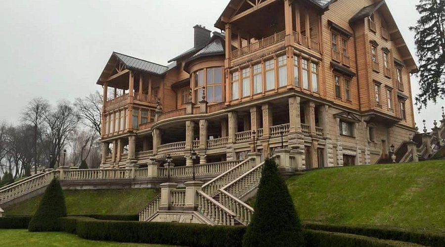
Former President Viktor Yanukovych lived at the Mezhyhirya Palace, commonly known as “the Museum of Corruption,” from 2002 to 2014. Yanukovych’s decadent estate was once a monastery, but was closed by the Bolsheviks in 1923 after the Soviet Union was established.
The estate is now a state-owned museum, which opened to the public in 2014 as a visible reminder of the former president’s extravagant and opulent lifestyle. Yanukovich fled to Russia following the Maidan Revolution of 2014. After he left the palace, the Automaidan activists looked after it and kept it from being robbed until it was converted into a state-owned public park.
The estate consists of almost 350 acres of manmade lakes and lush gardens along the Dnieper River.
4 Traditional Food

Varenyky, also known as pierogis in some parts of Western Ukraine, are traditional dough dumplings stuffed with mashed potatoes and fried onions, minced pork, or pickled cabbage. They can also be filled with fruit, such cherries, and served with sour cream and honey for dessert.
If you want, you can take a cooking class in Kiev and learn how to create varenyky. First, dough is produced by combining flour, salt, butter, and evaporated milk, then kneaded and molded into a ball that is rested for 30 minutes. The dough is then smoothed out to a thin, flat layer and cut into 3-inch rounds.
We placed pre-boiled sour cherries in the center, folded the dough in half, and pressed the edges. The stuffed pastries were boiled briefly and served hot. A great and enjoyable experience!
5 Andriivskyi Descent
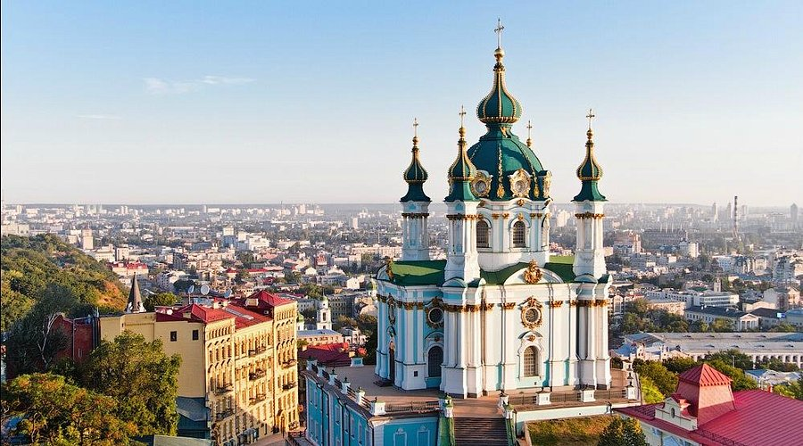
Andriivskyi Descent is a historic cobblestone route in Kyiv, Ukraine that connects the city’s Upper Town to the Podil area. Often referred to as the “Montmartre of Kyiv,” it is a popular tourist destination recognized for its art galleries, souvenir stores, and attractiveness, as well as the placement of St. Andrew’s Church at the top end. The roadway is around 735 meters long.
It is a popular tourist destination, recognized for its artistic and historical aura, and is frequently compared to Paris’ Montmartre.
Concluding
Ukraine is safe as long as you avoid Crimea, which is located in the country’s far east and is embroiled in a territorial conflict with Russia. The US Department of State has issued a caution to US residents to postpone all travel to the Crimean peninsula, although there are no limitations on visiting Kiev or other lovely towns such as Odessa and Lviv.
Ukrainians are friendly and welcoming, although the majority do not speak English, however this is changing among the younger generation. And then there’s the completely unknown Cyrillic alphabet. These are the factors to consider when organizing a vacation to Ukraine.
Thane’s real estate market is booming, with people flocking to acquire properties. Because of its excellent connectivity and infrastructure, selecting a reputed builder is becoming increasingly vital today. The best builders offer premium, mid-range, and low-cost housing, as well as stunning designs that ensure your investment is completely secure. The best list of Thane’s top ten builders and developers may connect you with reliable builders who fit your lifestyle and needs. You can start working on purchasing your dream home and investment opportunity in Thane right away.
Top 10 Builders and Developers in Thane
Here is a list of Thane’s greatest builders and developers, known for excellent construction, on-time delivery, and dependable residential developments, to assist homeowners and investors in selecting the right developer:
1) Rustomjee Constructions
Rustomjee Group, founded in 1995 by Boman R. Irani, is a notable real estate developer in the Mumbai Metropolitan Region (MMR). They are well-known for their meticulous design and environmentally friendly construction, having completed over 300 projects ranging from residential townships to luxury high-rises and commercial spaces.
| Attribute | Details |
| Builder Name | Rustomjee Constructions [1] |
| Headquarters | 702, Natraj, M.V. Road Junction,Western Express Highway, Andheri (East),Mumbai – 400 069 |
| Years of Experience | 30 years |
| Notable Thane & Mumbai Projects | Uptown Urbania La Familia / Rustomjee Crown / Rustomjee Verdant Vistas / Rustomjee Crescent / Rustomjee Belle Vue / Uptown Urbania La Vie |
| Project Category | Residential / Plots / Commercial / Townships |
| Price Range | On Request (premium segment) |
| Possession Status | 2 & 3 bed homes starting at ₹3.33 Cr++ / Rustomjee Vista Bay |
| Amenities | Clubhouse, pool, gym, sports courts, gardens, jogging track, kids’ play area |
| Safety & RERA Compliance | RERA registered (verify on Maha RERA portal) |
| Project Segments | 2, 3 & 4 BHK apartments, Penthouses & residential plots |
| Contact | Phone: +91 22 6111 6111Email: sales@rustomjee.com / nri@rustomjee.com |
2) Godrej Group
Godrej Properties brings the Godrej Group’s innovation, sustainability, and excellence ideals to the real estate market. Godrej Properties’ 123-year legacy of excellence and trust is blended with a dedication to modern architecture and technology in all of its projects. This is the best builder in Thane. Over the years, Godrej Properties has received more than 250 accolades and awards. Our organisation has consistently been at the forefront of the environmental sustainability movement. These initiatives are Godrej Ascend, Godrej Emerald Vista, and Godrej Exquisite.
| Attribute | Details |
| Builder Name | Godrej Properties [2] |
| Headquarters | Mumbai – Unit No. 5C, 5th Floor, Godrej One, Pirojshanagar, Vikhroli East, 400 079 |
| Years of Experience | 30+ years |
| Notable Ghaziabad Projects | Godrej Wave City, Godrej Siddharth Vihar, Godrej Plots Siddharth Vihar |
| Project Category | Residential / Plots / Township |
| Price Range | On Request (premium segment) |
| Possession Status | Wave City: ~2029+Siddharth Vihar: Pre-launch |
| Amenities | Clubhouse, pool, gym, sports courts, gardens, jogging track, kids’ play area |
| Safety & RERA Compliance | RERA registered (verify on UP RERA portal) |
| Project Segments | 2, 3 & 4 BHK apartments, residential plots |
| Contact | Phone: +91 22 6169 8500Email: marketing@godrejproperties.com |
3) Kalpataru Group
Kalpataru Group, India’s premier real estate developer, was founded in 1969. It has successfully launched several important projects, setting new standards in the real estate market. The company’s distinctive strategy focuses on developing residential and commercial properties that have future value for clients. This builder is well-known in Thane. The Group’s defining characteristics are quality, honesty, humility, and openness. It aims to be recognized for its innovative, high-quality, and deliberately designed living places.
| Attribute | Details |
| Company Name | Kalpataru Ltd [3] |
| Headquarters | Kalpataru Ltd, 101, Kalpataru Synergy, Opp. Grand Hyatt, Santacruz (E), Mumbai – 400 055 |
| Years of Experience | 50+ years (established 1969) |
| Notable Ghaziabad/Noida Projects | Kalpataru Vista – Sector 128, Noida (close to Ghaziabad region) |
| Project Category | Residential (Premium 3 & 4 BHK) |
| Price Range (sq ft.) | ₹5.7 Cr‑₹7.6 Cr+ (3 & 4 BHK) |
| Possession Status | Under Construction / Ongoing (Possession around June 2025) |
| Booking Amount | On Request (contact sales) |
| Amenities + Specifications | Golf‑course views, clubhouse, pool, gym, kids’ play area, landscaped gardens, 24×7 security |
| Safety & RERA Compliance | RERA Registered (UPRERAPRJ14980) |
| Project Segments | 3 & 4 BHK apartments + duplexes |
| Total Projects | 100+ projects (India nationwide) |
| Under Construction Projects | Kalpataru Vista – Sector 128 (Noida) |
| Upcoming Projects | No official projects in Thane; upcoming residential projects planned in Noida/NCR region |
| Contact | Phone: +91‑22‑3064 5000Email: sales@kalpataru.com |
4) Hiranandani Group
Hiranandani Group is a prominent top developer in Thane with over 40 years of experience. Since its founding in 1978, the Hiranandani Group’s success has been built on the confidence of the people, and their unshakable faith motivates us to continue aiding others. Numerous families who have built a future with us can attest to the value they have added to their lives. They use technological advancements in our real estate projects to assure perfection and precision in all aspects, because they recognize the power of technology. Our ultimate goal is to give people a fantastic experience.
| Attribute | Details |
| Company Name | Hiranandani Group [4] |
| Headquarters | Olympia, Central Avenue, Hiranandani Business Park, Powai, Mumbai – 400076 |
| Phone | +91 22 2576 3600 |
| sales@hiranandani.net | |
| Website | https://hiranandani.com/ |
| Years of Experience | 40+ years |
| Notable Thane Projects | Hiranandani Estate (Ghodbunder Road)Hiranandani Westgate (Waghbil) |
| Project Category | Residential Townships & Premium Apartments |
| Price Range (sq ft.) | ~₹95 L – ₹8 Cr+ (1–4 BHK) |
| Possession Status | Under Construction / Ongoing (Westgate ~Dec 2029) |
| Booking Amount | On Request |
| Amenities + Specifications | Clubhouse, swimming pool, gym, sports courts, landscaped gardens, kids’ play areas, jogging track |
| Safety & RERA Compliance | RERA Registered (verify specific RERA numbers before booking) |
| Project Segments | 1, 2, 3 & 4 BHK apartments |
| Total Projects | Multiple townships across Mumbai, Thane, Navi Mumbai, Pune & Chennai |
| Under Construction Projects | Hiranandani Estate (Ghodbunder Road), Hiranandani Westgate (Waghbil) |
| Upcoming Projects | No official upcoming projects in Thane; new projects planned in Mumbai, Navi Mumbai, Pune, & Chennai |
| Contact | Phone: +91 22 2576 3600Email: sales@hiranandani.net |
5) Runwal Developers
With a proven track record of 51 completed projects and over 10,000 satisfied families, the business has always prioritized the “customer” in all project design, planning, and implementation. The Runwal Group currently owns and operates Mumbai’s largest retail mall complex, R City Mall, R Mall, and R Odeon, which covers more than 2 million square feet of G.L.A. The Runwal Group specializes in luxury, premium, and large-format township residential projects.
| Attribute | Details |
| Company Name | Runwal Developers / Runwal Group [5] |
| Headquarters | Runwal & Omkar Esquare, 5th Floor, Eastern Express Highway, Sion (East), Mumbai – 400022 |
| Phone | +91 22‑61133000 |
| corporate@runwal.com | |
| Website | https://www.runwal.com/ |
| Years of Experience | 45+ years (since 1978) with 65+ projects delivered across Mumbai MMR & Pune |
| Notable Thane Projects | Runwal One Thane West (1 & 2 BHK, Manpada)Runwal Gardens (Dombivli East township) |
| Project Category | Residential Apartments & Integrated Townships |
| Price Range (sq ft.) | Runwal One Thane: ~₹69 L‑₹1.1 Cr+ (1 & 2 BHK)Runwal Gardens: ~₹38 L‑₹1.8 Cr (1‑3 BHK) |
| Possession Status | Runwal One Thane West: Under Construction (Dec 2028)Runwal Gardens: Possession ongoing/varies by tower |
| Booking Amount | On Request / Contact Sales |
| Amenities + Specifications | Clubhouse, gym, swimming pool, landscaped gardens, jogging track, play areas (varies by project) |
| Safety & RERA Compliance | RERA Registered (e.g., Runwal One Thane West RERA: P51700046298) |
| Project Segments | 1, 2 & 3 BHK residential |
| Total Projects | 65+ landmarks delivered across Mumbai, MMR & Pune |
| Under Construction Projects | Runwal One Thane West; Runwal Gardens (selected phases) |
| Upcoming Projects | No official upcoming projects in Thane; new launches planned in Mumbai & Pune regions |
| Contact | Phone: +91 22‑61133000Email: corporate@runwal.com |
6) Tata Housing Development Company Ltd.
With the fastest growth rate since 2006, TATA Housing has become one of India’s top real estate development companies. With an emphasis on residential, commercial, and retail property development, Thane’s real estate developers operate in a number of industries. The company is renowned for its meticulous property management, ethical and transparent business practices, and excellent building work. It has worked with internationally recognized designers and architects. In India, TATA Housing was the first company to build commercial real estate.
| Attribute | Details |
| Company Name | TATA Housing [6] |
| Headquarters | Homi Modi St, Kala Ghoda, Fort, Mumbai, Maharashtra – 400001 |
| Phone | +91 (22) 6665 8282 |
| info@tata.com | |
| Website | https://www.tata.com/business/tata-housing |
| Years of Experience | 20+ years in real estate development |
| Notable Thane Projects | Tata Eureka Park (Kolshet, Thane West) |
| Project Category | Residential Apartments & Townships |
| Price Range (sq ft.) | ~₹90 L – ₹4 Cr+ (1–4 BHK) |
| Possession Status | Under Construction / Ongoing |
| Booking Amount | On Request / Contact Sales |
| Amenities + Specifications | Clubhouse, swimming pool, gym, landscaped gardens, jogging track, kids’ play areas |
| Safety & RERA Compliance | RERA Registered |
| Project Segments | 1, 2, 3, & 4 BHK residential |
| Total Projects | Multiple projects across Mumbai, Thane, Pune, and other regions |
| Under Construction Projects | Tata Eureka Park (Thane West) |
| Upcoming Projects | No official upcoming projects in Thane; new projects planned in the Mumbai and Pune regions |
| Contact | Phone: +91 (22) 6665 8282Email: info@tata.com |
7) Raunak Group.
They are a well-known and recognized builder and developer in Thane and Mumbai, having been in operation since 1980. Our primary goal is to continue providing our clients with the greatest possible experience from the moment they begin the home-buying process until they retire.
They have completed several township projects over the years. They have completed projects totaling over 59,58,787 square feet and are now working on projects that will add 44,19,277 square feet.
| Attribute | Details |
| Company Name | Raunak Group [7] |
| Headquarters | Plot No.1, Mohan Mill Compound, Ghodbunder Road, Thane (W) – 400607 |
| Phone | (+91) 22‑25847000 |
| info@raunakgroup.com | |
| Website | https://raunakgroup.com/ |
| Years of Experience | 35+ years |
| Notable Thane Projects | Raunak Bliss (Thane West), Raunak City (Ghodbunder Road) |
| Project Category | Residential Apartments & Townships |
| Price Range (sq ft.) | ~₹60 L – ₹3 Cr+ (1–3 BHK) |
| Possession Status | Raunak Bliss: Under ConstructionRaunak City: Ongoing |
| Booking Amount | On Request / Contact Sales |
| Amenities + Specifications | Clubhouse, swimming pool, gym, landscaped gardens, jogging track, kids’ play areas |
| Safety & RERA Compliance | RERA Registered |
| Project Segments | 1, 2 & 3 BHK residential |
| Total Projects | Multiple residential projects in the Thane and Mumbai regions |
| Under Construction Projects | Raunak Bliss, select towers of Raunak City |
| Upcoming Projects | No official upcoming projects in Thane; other upcoming projects in the Mumbai region |
| Contact | Phone: (+91) 22‑25847000Email: info@raunakgroup.com |
8) Regency Group.
The Regency Group’s Chairman and Managing Director, Mr Mahesh Agarwal, its founder and predecessor, leads the company professionally.
Thane’s real estate businesses operate with a focus on quality, quantity, and efficiency, earning them an enviable reputation. If you are looking for a house in Thane, you should speak with a home loan specialist to assess your eligibility.
| Attribute | Details |
| Company Name | Regency Group [8] |
| Phone | +91 0251‑6161000 |
| Website | https://regencygroup.co.in/ |
| Years of Experience | 30+ years |
| Notable Thane Projects | Regency Towers, Regency Heights (Thane West) |
| Project Category | Residential Apartments & Townships |
| Price Range (sq ft.) | ~₹50 L – ₹2 Cr+ (1–3 BHK) |
| Possession Status | Under Construction / Ongoing |
| Booking Amount | On Request / Contact Sales |
| Amenities + Specifications | Clubhouse, swimming pool, gym, landscaped gardens, jogging track, kids’ play areas |
| Safety & RERA Compliance | RERA Registered |
| Project Segments | 1, 2 & 3 BHK residential |
| Total Projects | Multiple residential projects across Thane and the surrounding regions |
| Under Construction Projects | Regency Towers, Regency Heights |
| Upcoming Projects | No official upcoming projects in Thane; new projects planned in nearby regions |
| Contact | Phone: +91 0251‑6161000 |
9) Cosmos Group.
The organization, founded in 2000 by Mr. Suraj Parmar, Mr. Pradip Chopra, and Mr. Manish Mehta, takes pleasure in its integrity, excellence, and exceptional work. The Group’s founders have 30 years of construction experience and have created townships in Virar, Vasai, Thane, and Nallasopara. Their remarkable work has earned them widespread recognition in a variety of sectors.
| Attribute | Details |
| Company Name | Cosmos Group [9] |
| Headquarters | B‑183/184, G.I.D.C., Sector‑25, Near Madhur Dairy, “K” Road, Gandhinagar – 382025 |
| Phone | 9324183942 |
| cspaliwal@cosmosgroup.in | |
| Website | https://www.cosmosgroup.in/ |
| Years of Experience | 30+ years |
| Notable Thane Projects | Cosmos Kalpataru (Thane West), Cosmos Palms (Ghodbunder Road) |
| Project Category | Residential Apartments & Townships |
| Price Range (sq ft.) | ~₹50 L – ₹2 Cr+ (1–3 BHK) |
| Possession Status | Under Construction / Ongoing |
| Booking Amount | On Request / Contact Sales |
| Amenities + Specifications | Clubhouse, gym, swimming pool, landscaped gardens, jogging track, kids’ play areas |
| Safety & RERA Compliance | RERA Registered |
| Project Segments | 1, 2 & 3 BHK residential |
| Total Projects | Multiple residential projects across Thane and the surrounding regions |
| Under Construction Projects | Cosmos Kalpataru, Cosmos Palms |
| Upcoming Projects | No official upcoming projects in Thane; new projects planned in other regions |
| Contact | Phone: 9324183942Email: cspaliwal@cosmosgroup.in |
10) Rosa Group.
All of the Rosa Group’s homes are built on the firm premise that “meeting client expectations is simply the first step; exceeding them is our endeavour” in a world where construction is largely about producing beautiful structures. To stay up with business trends and technology, the best machinery, most effective workers, qualified colleagues, and efficient equipment are utilized and regularly improved. Rosa Group is a building company that pioneered the concept of interconnected master-planned communities. The Group has changed Thane’s real estate industry.
| Attribute | Details |
| Company Name | Rosa Group (Rosa Realty Group) [10] |
| Headquarters | Rosa Manhattan, Next to Rosa Royale, Near Hiranandani Estate, Ghodbunder Road, Thane West – 400607 |
| Phone | +91 8767607607 |
| sales@rosagroup.in | |
| Website | https://www.rosagroup.in |
| Years of Experience | Founded in 2009; 15+ years in real estate |
| Notable Thane Projects | Rosa Manhattan, Rosa Sephora, Rosa Royale |
| Project Category | Residential Apartments & Luxury Townships |
| Price Range (sq ft.) | ~₹1.70 Cr – ₹2.05 Cr (2–3 BHK units at Rosa Manhattan, Ghodbunder Road) |
| Possession Status | Mix of Ready-to-Move and Under Construction projects |
| Booking Amount | On Request / Contact Sales |
| Amenities + Specifications | Clubhouse, landscaped gardens, gym, swimming pool, jogging track, kids’ play areas |
| Safety & RERA Compliance | All projects are RERA Registered |
| Project Segments | 2 & 3 BHK luxury apartments |
| Total Projects | 8+ residential projects in Thane |
| Under Construction Projects | Rosa Manhattan, Rosa Sephora |
| Upcoming Projects | New launches planned in Thane’s Ghodbunder Road and Bhayandarpada region |
| Contact | Phone: +91 8767607607Email: sales@rosagroup.in |
How to Choose the Best Builder in Thane?
Choosing the right builder is crucial for ensuring high-quality construction, timely delivery, and long-term value. Here are the key factors to consider:
Step 1: Check the UP RERA Registration for the project’s approval status and developer reputation.
Step 2: Consider the contractor’s track record of completing tasks on time.
Step 3: Evaluate construction quality, including materials, construction, and project completion.
Step 4: Determine a construction company’s financial health to avoid project delays.
Step 5: Consider the project’s position in respect to public transportation choices such as Metro lines, roads, schools, and offices.
Step 6: Compare the prices to the features and specifications provided by the facility.
Step 7: Clearly record all payments, reception deadlines, and other legal matters.
Step 8: Analyze client feedback and comments to identify consumer satisfaction and recurring issues.
Step 9: Determine the resale value/rental returns dependent on the construction company’s reputation.
Step 10: Evaluate service quality in terms of maintenance and warranty.

Mumbai’s Bandra Kurla Complex (BKC) is preparing to launch a new program aimed at decreasing congestion and encouraging sustainable travel. Every Friday will be designated as ‘Public Transport Day’, with approximately 200,000 professionals encouraged to take the train, metro, or bus instead of driving their own cars. The program, a first-of-its-kind initiative centered on a major corporate district, will begin this week, on June 12.
Why was Friday chosen?
Around 90 BKC-based firms and organisations have shown their support in principle to the initiative. It is being implemented by the Mumbai Metropolitan Region Development Authority (MMRDA) in collaboration with BEST, Mumbai Metro Rail Corporation Limited (MMRCL), the Traffic Police, auto-rickshaw unions, and WRI India, according to the Hindustan Times (HT).
According to authorities, Fridays were chosen because work schedules are often more flexible near the end of the week, making employees more ready to try other transport options. Mondays were avoided since commuters are normally under more strain to get to work on time.
The MMRDA has also directed almost 2,000 employees and contract workers to engage in the campaign.
How long will the trial last?
Officials stated that the program will be rigorously watched for at least three to four months. During this time, authorities will assess difficulties every week and implement changes as needed.
The move comes after surveys and stakeholder consultations conducted in recent weeks. According to the findings, 82% of commuters would consider taking public transportation if services were more reliable, convenient, and well-connected.
What issues are commuters most concerned about?
According to feedback obtained during conversations, the most pressing issues concern last-mile connectivity from Aqua Line metro stations, pedestrian amenities within BKC, a lack of shade for pedestrians, and the need for more regular BEST bus services.
“Getting out of the metro station is quick, but finding a shared auto or a feeder bus to cover the remaining one to two kilometers inside BKC is a daily nightmare,” an executive from a big financial firm told HT.
“If last-mile connectivity isn’t smooth, people will naturally return to their vehicles. There is a need for robust bus services with frequencies of 5-10 minutes instead of the current 20-25 minutes.”
Why do so many commuters still use private vehicles?
According to MMRDA officials, poor last-mile connectivity remains a significant barrier.
“There are challenges with last-mile connection in BKC, therefore 52% of visitors still rely on personal cars, taxis, and auto-rickshaws. Furthermore, more than half of BKC’s 200,000 employees spend more than two hours commuting each day. We will also consult with the auto-rickshaw unions to ensure that this plan is effective,” an MMRDA official told HT.
According to studies provided during debates, 52% of commuters still rely on private vehicles, taxis, and auto-rickshaws, while only 25% use public transportation on a daily basis.
Experts cited poor last-mile connections from Aqua Line stations and insufficient pedestrian infrastructure as major causes for low public transportation usage.
What upgrades are planned?
Authorities and partner agencies have been working with BKC businesses to find urgent and long-term solutions.
Dedicated turning facilities for BEST buses at major junctions are one of the concepts being considered to increase service efficiency. Officials are also looking into whether internal roadways on large office campuses may be made pedestrian-friendly to provide shorter walking routes.
Urban mobility experts indicated that boosting walkability will be critical to the initiative’s success. They observed that walking in BKC is uncomfortable due to the broad concrete expanses and lack of tree protection, especially in hot weather.
Planners have proposed shaded pedestrian pathways, more tree cover, and better connections between metro stations and office buildings.
“There are long-term plans such as all-weather footpaths as well wherein we can have shades with plants overarching the roofs, mist blowers and plain footpath among other things,” an urban planner stated.
How will you persuade staff to participate?
Officials and corporate representatives have also explored incentives for behavioral change. Regular public transportation users could benefit from reward systems, recognition programs, and travel expense compensation.
“Meaningful change starts with each of us. My entire staff and I have committed to supporting this initiative by taking public transportation on Fridays. Dr Sanjay Mukherjee, metropolitan commissioner of MMRDA, told HT that even little changes can dramatically cut congestion and pollution.
Walking Project’s programme manager, Vedant Mhatre, applauded the effort, saying it might assist enhance both public transportation utilization and walking conditions in BKC.
“The project acknowledges the need to shift more trips to public transportation. We hope it will also provide an opportunity to make basic but significant changes to BKC’s walking infrastructure, such as safer junctions, better walking corridors, improved shading, and increased pedestrian comfort. These steps can considerably improve the experience of walking and taking public transportation. We are thrilled that MMRDA has taken the lead on this endeavor, and the Walking Project is eager to contribute feedback, suggestions, and practical improvements.”
Introduction
Mumbai offers a variety of options, from luxury real estate to mass housing constructions. The city offers housing options for people of all income levels and strikes the perfect mix between elegance and reality. Mumbai’s inexpensive cost of living, abundant employment opportunities, and advanced infrastructure make it a desirable destination for prospective homebuyers. If you’re looking for a home in a posh part of Mumbai, here are some of the city’s most expensive neighborhoods.
Top 7 Posh Areas in Mumbai.
These are the top seven posh areas in Mumbai where buying a home can be quite expensive. However, the quiet surroundings and sea views from high-rise buildings are worth the cost.
Juhu
Juhu, sometimes known as Bollywood’s Beverly Hills, is an upmarket enclave in Mumbai’s western suburbs. There are a range of independent builder levels and low-rise structures. The Arabian Sea to the west offers spectacular views of nature. Furthermore, the neighborhood has exceptional connection, superb infrastructure, and first-class amenities.
Malabar Hill
Malabar Hill is another affluent suburb in Mumbai’s southern zone. Aside from being a prominent residential community. It is the most expensive site in Mumbai, situated on the city’s southern tip and offering views of the Arabian Sea on three sides. The primary attractions are Seaside Chowpatty and the Hanging Gardens. Furthermore, the area has a wide range of social amenities and world-class physical infrastructure.
Cuffee Parade
Cuffe Parade, located at Nariman Point in the city’s south end, was constructed on 75,000 square metres of land on Colaba’s western bank. Today, it is one of Mumbai’s most affluent neighborhoods. Maker Towers, the World Trade Center, and the Taj President Hotel are among the region’s residential and business high-rises. What identifies it as a luxury neighborhood in Mumbai is the presence of first-rate amenities and well-maintained infrastructure.
Bandra West
Bandra West is another Mumbai VIP area with a wide range of property options. It is especially well-known for its famous homes. In addition to being a rich district in Mumbai, it is a popular entertainment destination, having a variety of high-end restaurants, discotheques, and nightclubs. Furthermore, it is well connected to Worli by the Bandra-Worli Sea Link and has excellent medical services and schools.
Pali Hill
Palli Hill is an upscale area named after the Pali village in Bandra. It runs across Naushad Ali Road (previously Carter Road) and has a variety of complexes, restaurants, and bungalows with steep and shallow sides. Furthermore, it boasts cutting-edge infrastructure and convenient access to all modern facilities.
Worli
Worli, one of Mumbai’s four peninsulas, is a well-connected neighborhood in southern Mumbai. It is home to several celebrities. The region is surrounded by high-rise buildings with panoramic views of the Bandra-Worli Sea Link, the Race Course, and the Arabian Sea. Aside from being Mumbai’s most upscale neighborhood, it is home to a diverse range of commercial establishments, including restaurants, nightclubs, and shopping malls. Its proximity to commercial centers makes it a popular choice for office workers.
Colaba
Colaba is another popular residential neighborhood in Mumbai. It is a separate district that acts as the city’s art and cultural center. Colaba is a heritage district that includes high-end boutiques, museums, theatres, art galleries, and colonial structures. Aside from its excellent connectivity, Colaba is home to some of the top educational and healthcare institutions.
The Most Expensive Areas in Mumbai: Real Estate Prices
Mumbai is a booming metropolis with a steady demand for real estate. Scarce land resources due to surrounding water bodies aggravate competition and drive up housing prices. Real estate prices in Mumbai are higher in areas with scenic views, entertainment attractions, and commercial districts. Homebuyers must pay higher prices for properties in areas with adequate infrastructure, public facilities, transit networks, and convenient access to highways and airports.
Price Trend of Posh Areas in Mumbai
While Mumbai is one of the most expensive cities in India to buy a home, some areas have exorbitant real estate prices. Cuffe Parade, Pali Hill, Bandra, Malabar Hill, and Colaba are some of Mumbai’s most expensive suburbs. However, high real estate prices may not always indicate a healthy property market. The Mumbai property market has slowed in recent years due to the pandemic and the economic downturn. Despite this, a premium neighbourhood in Mumbai continues to entice wealthy investors and buyers with its unique features. These neighborhoods offer class and distinction, which many homeowners are ready to pay for.

Jamnabai Narsee International School to Open New Juhu Campus in ₹800 Crore Lease Deal

Vidhu Vinod Chopra Buys ₹7.75 Crore Apartment in Mumbai’s Bandra

Maharashtra Court Backs Society’s Right to Clamp Illegal Vehicles

Vijayta Raheja Applauds India’s ₹4 Lakh Crore Urban Vision at ET Maharashtra Business Summit

K Raheja & IHG Team Up to Elevate Powai’s Hospitality Landscape

John Abraham Firm Renews Bandra Rent at ₹12L/Month
-
 Real Estate News3 months ago
Vijayta Raheja Applauds India’s ₹4 Lakh Crore Urban Vision at ET Maharashtra Business Summit
-
 New Projects & Launches3 months ago
K Raheja & IHG Team Up to Elevate Powai’s Hospitality Landscape
-
 Real Estate News3 months ago
John Abraham Firm Renews Bandra Rent at ₹12L/Month
-
 Real Estate News3 months ago
Mumbai’s Largest MHADA Redevelopment Drive Set to Transform 923 Acres
-

 NRI Real Estate3 months ago
How NRIs Are Driving India’s Property Market?
-
 Global Real Estate3 months ago
Spanish Youth Hostel Group Considers London Real Estate Deals
-

 NRI Real Estate3 months ago
Will NRI Investments Drive Mumbai Housing?
-
 Global Real Estate3 months ago
Northfield Sees New Affordable Housing Underway